





Meniu
Secure & trustworthy Your data is safe
24/7 dedicated support We're always here for you
Trusted partner Solutions for your business

VOGO eBS GIS

GIS for any organisation, integrated with any system

Maps on case files, spatial analyses done by the system, web applications and dashboards — with the rights of VOGO eBS and with standard services for any other application.

Utilities, administration, environment, transport, health, emergencies: the same module, each field with its own layers, in the national projection.

  • Any field
  • OGC services and API
  • The rights of the case file
VOGO eBS GIS

Geospatial information where decisions are made — in any field

The map no longer sits in a separate system: it opens from the case file you are working on, with its object — a network, a parcel, a site, a route — and with the organisation’s reference layers. Whoever sees the case file also sees it on the map; whoever can change it saves the map as a document and shares it.

The system does the spatial analyses: intersections, areas, buffer zones, distances, statistics, on the layers of each field. For a utility company that means the network and the interventions; for a city hall, urban planning and the cadastre; for an environmental authority, the protected sites and the water bodies.

The module does not lock the data inside VOGO eBS: layers are published as standard OGC services, external applications use the GIS service through an API, analysts work on the same database from QGIS Desktop, and the rest of the organisation builds web applications from templates, without programming.

One GIS module. Any field. Any system.

A map for every case file, straight from the application

Every record, case or object in VOGO eBS has its map: the site, the network, the parcel or the route, over the organisation’s reference layers, in the national projection. Layers are added from the catalogue, from files or from WMS/WFS services, styled and filtered without code, and the map is saved as a document in the case file.
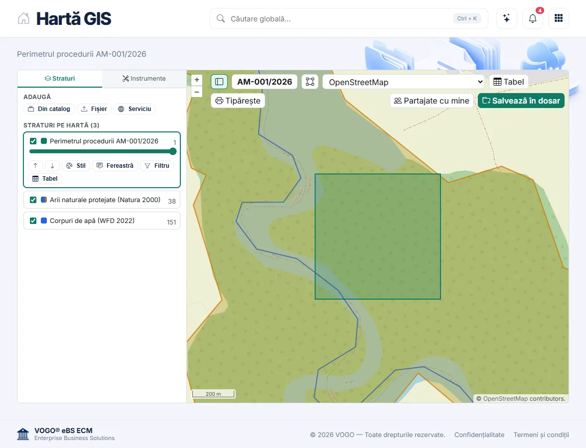
The GIS Map screen: the perimeter of procedure AM-001/2026 over the Natura 2000 site Lunca Mijlocie a Argeșului

Spatial analyses done by the system

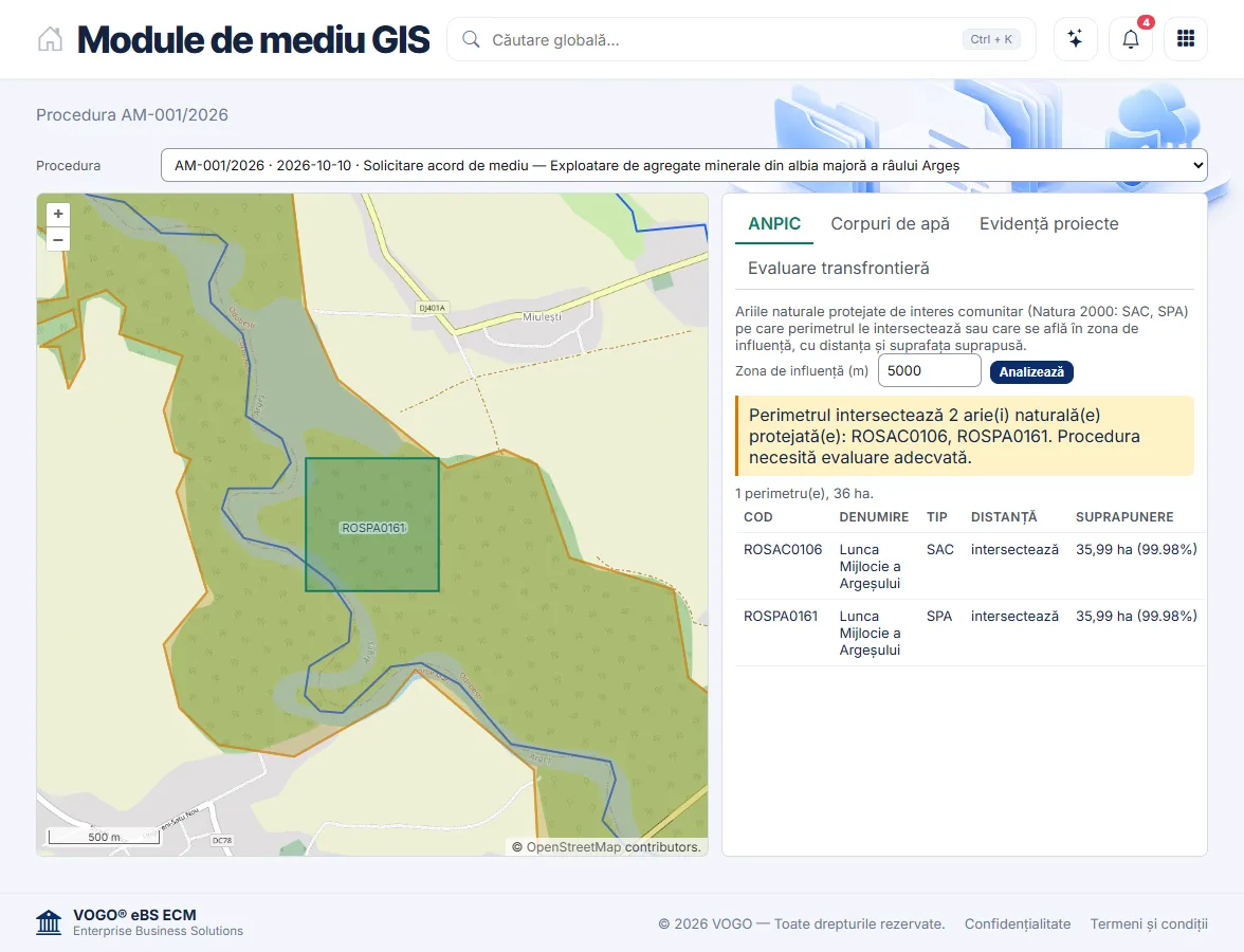
Intersections, overlapping areas, buffer zones, distance to the nearest object: the checks are configured on the organisation’s layers and run by themselves, on every case file. In the example shown, an environmental permit: the project perimeter against the Natura 2000 sites.

The ANPIC module: the perimeter intersects sites ROSAC0106 and ROSPA0161, with the overlapping area

Dashboards on the map

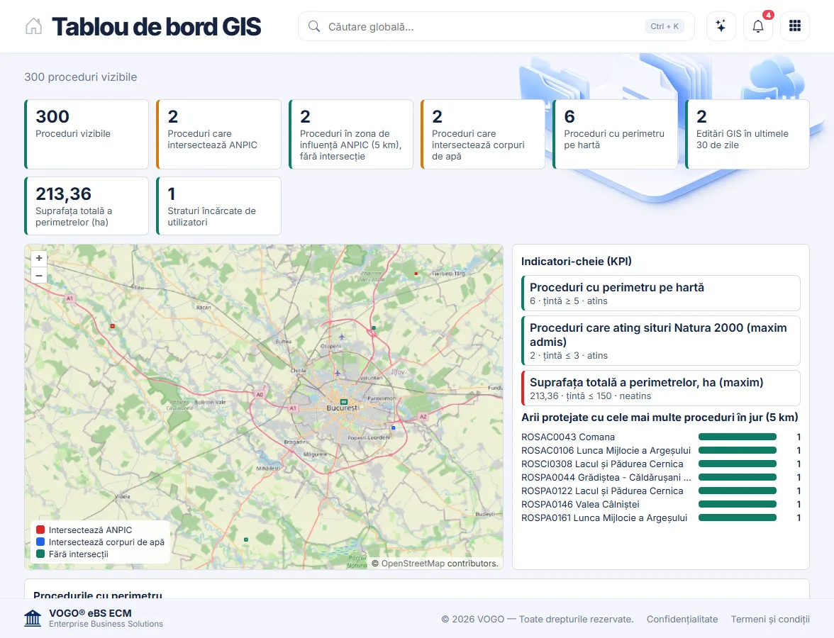
Activity indicators computed from the spatial data: how many case files fall in an area, what surface they cover, what findings they have. Key indicators have targets set by the organisation, and the map colours every object by its result.

The GIS dashboard: indicators, KPIs with targets and the map of the perimeters

Web applications built without programming

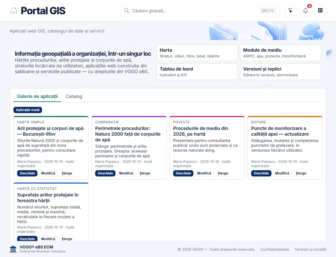
From five templates — simple map, statistics on the visible area, side-by-side comparison, editing and map story — every department builds the application it needs and shares it with the right groups or with the whole organisation.

The GIS portal: the gallery of web applications built from templates

The rights of VOGO eBS

Whoever sees a case file in the application also sees it on the map. The GIS server applies exactly the application’s rights, with no separate accounts.

National projections, natively

Coordinates are imported from Excel, CSV, Shapefile, KML, GPX or GeoJSON, in the national projection (Stereo 70 for Romania, X north, Y east); WGS84 is recognised automatically.

Symbols and labels

Single symbol, by category or by range, transparency, display scale and labels, set on screen.

Filters without SQL

Conditions joined by AND / OR, built visually; the attribute table follows the selection on the map.

Web editing, with a log

For each layer you choose what can be edited — geometry, attributes or both —, with snapping and a full history.

Statistics on the visible area

Object count, sum, mean, minimum, maximum and the distribution of values, recalculated whenever the map moves.

Printing A4, A3, A2

The visible area is printed or exported as an image, with the title and page orientation you choose.

Integrates with any system

Layers are published as standard OGC services (WMS, WFS, WMTS, WPS), and external applications use the GIS service through an API, with the rights of VOGO eBS.

One GIS module, for any field

Utilities

Water, gas, power and district-heating networks: viewing, interventions, field readings, outages.

Public administration

Urban planning, cadastre, building permits, heritage, zoning plans.

Agriculture and environment

Parcels, protected areas, water bodies, permits and pollution monitoring.

Transport and logistics

Routes, fleets, warehouses, deliveries tracked on the map.

Public health

Outbreaks, licensed facilities, inspections with geographic traceability.

Telecommunications

Network planning, coverage maps, passive infrastructure.

Emergency management

Coordinating interventions, risk maps, evacuation plans.

Real estate and retail

Sites, feasibility studies, catchment areas and customers.

Example: four modules for environmental permitting

ANPIC

Automatic intersection of the perimeter with the protected natural areas of community interest (SAC, SPA), with the overlapping area and the buffer zone.

Water bodies

Automatic location of the project against the surface water bodies: those intersected and the nearest ones, with the distance.

Register of projects, plans and strategies

The perimeters of every procedure, imported from the coordinates sent by the applicant, with the area computed on import.

Transboundary assessment

The interactive map of the procedure, sent to the possibly affected states through a link with a PIN, limited validity and a log of every opening.

Every field brings its own reference layers — networks, parcels, sites, water bodies, routes — onto the same GIS server, with the same screens, the same rights and the same analyses.

Open-source components, OGC standards, integration with any system

PostGIS

The spatial database: geometries, indexing, SQL analyses, data versioning and replication.

GeoServer

Publishing layers as WMS, WFS, WMTS and KML services, and WPS geoprocessing.

QGIS Desktop & Server

The analyst’s workstation: topology, CAD editing, cartography, the same libraries on desktop and server.

OpenLayers

The map in the browser, in the national projection, on any screen.

VOGO eBS GIS Integrator

The GIS screens of VOGO eBS and the service that connects them to any application: the case-file map, the analyses, the portal, the dashboard, versions and replicas.

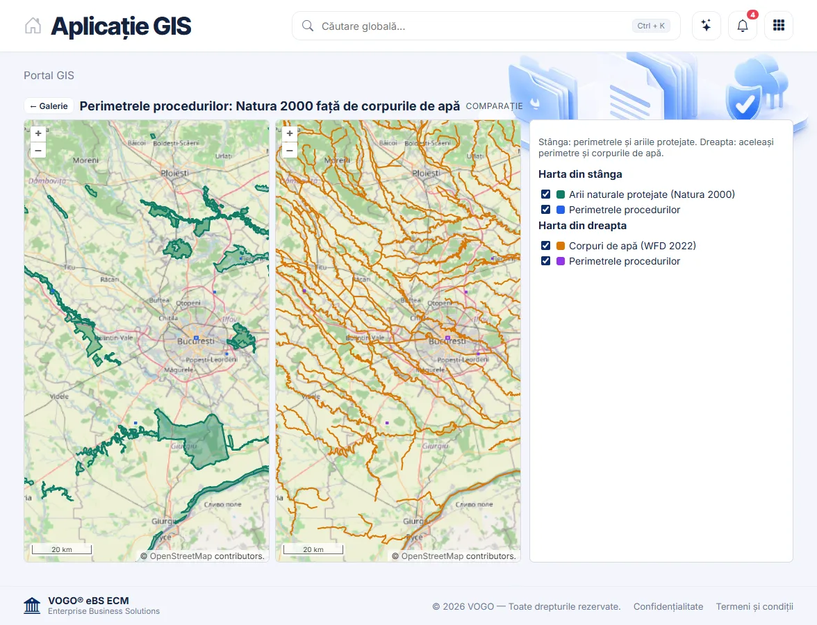
The comparison application: two synchronised maps with different sets of layers

Frequently asked questions

What is VOGO eBS GIS?

It is the geospatial module of the VOGO eBS platform: maps on case files, spatial analyses, web applications and dashboards, with the same accounts, rights and case files as the rest of the application. It serves any field in which data has a position on the map.

Can it integrate with other systems?

Yes. Layers are published as standard OGC services — WMS, WFS, WMTS, WPS, KML — that any GIS client reads, and external applications use the GIS service through an API, with the rights granted in VOGO eBS. Existing GIS systems are added to the catalogue as services.

Does it work with national coordinate systems?

Yes. In Romania the map and the data are in the national Stereo 70 projection (EPSG:3844); the applicant’s coordinates are imported with the Romanian convention, X north and Y east, and WGS84 is recognised automatically. Other national systems are handled through reprojection.

Which analyses does it run automatically?

Intersections and overlapping areas, buffer zones, distance to the nearest object and statistics on the visible area, on the organisation’s layers. For environmental permits, for example: the Natura 2000 sites touched by the perimeter and the water bodies crossed.

Can different editors work on the same data?

Yes. Each editor works in their own version; conflicts are detected and reconciled, and the published data changes only when a version is posted. Layers can be replicated to another server, one way or both ways.

Can it be used from QGIS?

Yes. QGIS Desktop connects to the same PostGIS database and the same GIS services; QGIS projects are published and used directly by VOGO eBS.

Where does it run?

On-premise, at the organisation, or in the cloud. The components are open source (PostGIS, GeoServer, QGIS, OpenLayers), and the data remains the organisation’s.

Request a demo

See how VOGO eBS GIS works

Request a demo on your organisation’s data and layers.

WhatsApp ebs@vogodigital.ro

Note: The services are provided in line with the European DNSH principle – “Do No Significant Harm”, in accordance with Article 17 of Regulation (EU) 2020/852 on the establishment of a framework to facilitate sustainable investment and with the European Commission’s technical guidance on the application of the DNSH principle, C/2023/111.